
Lahabali kɔligu:Hertfordshire UK locator map 2010.svg

Size of this PNG preview of this SVG file: 494 × 600 anfooni bihi bihi. Din pahi resolutions: 198 × 240 anfooni bihi bihi | 395 × 480 anfooni bihi bihi | 633 × 768 anfooni bihi bihi | 843 × 1,024 anfooni bihi bihi | 1,687 × 2,048 anfooni bihi bihi | 1,108 × 1,345 anfooni bihi bihi.
Faal maa maŋmaŋa (SVG lahabali kɔligu, nominally 1,108×1,345 pixels,lahabali koligu galisim:302 KB)
Lahabali jia
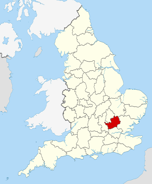
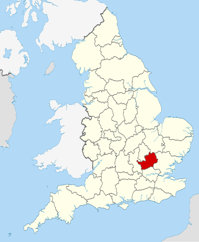
| Buɣisibu | Location of the ceremonial county of Hertfordshire within England. |
| Dabisili kalinli | |
| Nyabli |
National Geospatial-Intelligence Agency
|
| Sab'sabira | Nilfanion |
Fukumisi shahira niŋbu
I, the copyright holder of this work, hereby publish it under the following licenses:
Lahabali kɔligu ŋɔ nyɛla Creative Commons Attribution-Share Alike 3.0 Unported ni ti shɛli dihi tabili.
- A mali sɔli:
- N pirigi – Diyi lee ka a yan labi ŋma, n tari ka yan zaŋ tuma n talim
- Lab laɣim – n taɣi dee tuma maa
- N-yɛn zaŋ dɔli zalikpana ŋɔ sɔli:
- ŋmahindibu – Di tu ni a ti nin'tiɣili din tu, ka yooi sɔli din yihiri shiɛhira gbaŋ, ka lahi wuhi di yi niŋ ka taɣibu daa pun niŋ. A ni tooi niŋ lala ŋɔ n-doli hankali ni saɣi shɛm, amaa ka di pa sɔ'shɛli din mali biɛhiŋ zaŋ kpa ŋun tiri shiɛhira gbana ŋɔ polo nin'tiɣili ni nyini bee a zaŋ tum.
- Tarimi li din nyɛ shɛm – A yi mali labi sabi bee a taɣi li mi bee a miɛmi n-tam sabiri kurili maa zuɣu, di tu ni a tari a tɔhibu maa doli same or compatible license n-zali maŋ-maŋ maa.

|
Soli biɛni ni sabbu ŋɔ tooi yaai, n-tari ka/bee m-mali niŋ n-doli GNU zalisi Gbaŋ ŋmabu shahira gbaŋ din nyɛ yoli, Bali shɛli din nyɛ 1.2 bee bali shɛli dabam din na yɛn yina ka Free Software Foundation; yɛn zaŋ li bahina pɔhim zuɣu ka ka Invariant Yaɣa, ka ka Tooni-Gbaŋ Pɔbirili Sabbu, ka lahi ka Nyaaŋa-Gbaŋ Pɔbirili Sabbu. Lala shahira gbaŋ maa ŋmali nyɛla din be yaɣ' shɛli din yuli booni GNU Free Documentation License. |
A ni tooi pii shahira shɛli a ni bɔra.

|
This is one of the images forming part of the Valued image set: Locator maps of the Ceremonial counties of England on Wikimedia Commons. The image set has been assessed under the valued image set criteria and is considered the most valued set on Commons within the scope:
Locator maps of the Ceremonial counties of England
You can see its nomination at Commons:Valued image candidates/Locator maps of English ceremonial counties. |
Faal tarihi
Dihimi dabisili/saha n-nya kɔl' bihi kamani di ni di yina shɛm
| Zuŋɔ dabisili/Saha | Thumbnail | Di tarisi | ŋun su | tɔhibu | |
|---|---|---|---|---|---|
| din na chana | 22:38, 23 Silimin gɔli November 2010 | | 1,108 × 1,345 (302 KB) | Nilfanion | == Summary == {{Information |Description=Location of the ceremonial county of Hertfordshire within England. |Source=Ordnance Survey [https://www.ordnancesurvey.co.uk/opendatadownload/products.html OpenData]: *Coun |
Lahibali kɔligu zaŋ tum tuma
Din doli ŋɔ na yaɣili tuma nima zaŋ ti lahabali kɔligu ŋɔ:
Duniya zaa lahabali kɔligu zaŋ tum tuma
Wikis shɛŋa ŋan dolina ŋɔ gba malila faal ŋɔ n kuri bukaata:
- Zaŋ tum tuma af.wikipedia.org zuɣuc
- Zaŋ tum tuma an.wikipedia.org zuɣuc
- Zaŋ tum tuma ar.wikipedia.org zuɣuc
- Zaŋ tum tuma ast.wikipedia.org zuɣuc
- Zaŋ tum tuma az.wikipedia.org zuɣuc
- Zaŋ tum tuma be-tarask.wikipedia.org zuɣuc
- Zaŋ tum tuma be.wikipedia.org zuɣuc
- Zaŋ tum tuma bg.wikipedia.org zuɣuc
- Zaŋ tum tuma bn.wikipedia.org zuɣuc
- Zaŋ tum tuma br.wiktionary.org zuɣuc
- Zaŋ tum tuma ca.wikipedia.org zuɣuc
- Zaŋ tum tuma ceb.wikipedia.org zuɣuc
- Zaŋ tum tuma cs.wikipedia.org zuɣuc
- Zaŋ tum tuma en.wikipedia.org zuɣuc
- Hertfordshire
- Preston, Hertfordshire
- Ickleford
- River Rib
- Garston, Hertfordshire
- Colney Heath
- Weston, Hertfordshire
- Nasty, Hertfordshire
- Newmarket Ridge
- Bearton
- Pirton, Hertfordshire
- Gosmore
- Holwell, Hertfordshire
- Whitwell, Hertfordshire
- St Paul's Walden
- Lilley, Hertfordshire
- Graveley, Hertfordshire
- Hitchin Oughton
- Bendish
- Puckeridge
- Ayot Green
- Therfield Heath
- Datchworth
- Harpenden Rural
- Template:Hertfordshire-geo-stub
- Albury, Hertfordshire
- Charlton, Hertfordshire
- Anstey, Hertfordshire
- River Stort
- Aspenden
- Ayot St Peter
- Barkway
- Bengeo Rural
- Buckland, Hertfordshire
- Ridge, Hertfordshire
- Leverstock Green
Yulima more global usage zaŋ chaŋ lahabali kɔligu ŋɔ.